
| Fire
updates
Two Craig Mountain fires merge The Craig Mountain Complex fire, that started by lightning on Saturday, July 15 at Corral Creek and Powerline, by Monday, July 24 was at 1,826 acres at Corral Creek and 47,497 acres at Powerline. The two fires were merged due to successful burnout operations over the past few days and is in the winding down stage. The fire bordered by Deer Creek to the west and Cottonwood Creek to the east is south and southwest of Winchester There were 569 personnel on July 24, which includes three Type 1 (Hot Shot crews), 14 Type 2 hand crews and support personnel. On Sunday, July 23 it was up to 633 personnel. The Highland School in Craigmont was turned into the Incident Command Post with classrooms taken over throughout the building and various camps set up around it. The Lewis County Sheriffs office closed public access to the affect fire area at the intersection of Hoover Point and Soldier Meadows roads. The Bureau of Land Management Cottonwood Field Office has issued a temporary emergency closure order for the order for the Eagle Creek Road, from the intersection of Zaza Road to the Salmon River due to fire suppression activities and to ensure public health and safety. Recreationists floating the Salmon River will not be able to exit at Eagle Creek. The next take out location is at Heller Bar. As things improve the fire could be downgraded to a Type 3 which will cut down on the number of personnel. Updates and maps are posted on the Craig Mountain Complex Facebook site. 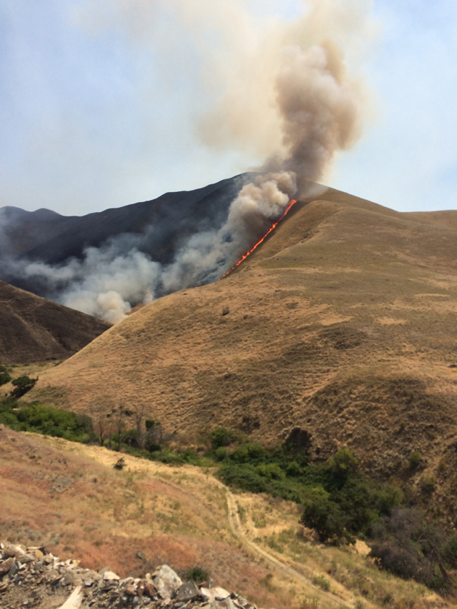
Photo ( by Josh Bransford): Crews conducting burnout operations around Garden Creek Ranch, also know as China Garden, to complete structure protection actions. This is from Saturday, July 22 on the Craig Mountain fires. Nez Perce National Forest fire update Several lightning-caused fires, detected July 14-16, 2017, on the Lochsa/Powell, Moose Creek, and Red River Ranger Districts are being monitored and crews are taking action as appropriate. Many are being managed for resource benefits. Firefighter and public safety remain the number one priority in wildland fire management and emergency response. The current National Preparedness Level is 4, meaning shared resources are heavily committed, competition exists for resources between Geographic Areas, and the potential for significant incidents emerging in multiple Geographic Areas indicates that resource demands will continue or increase. Current fire status by district: Lochsa/Powell Ranger District The Hidden and Maud fires are located in the Selway-Bitterroot Wilderness. They have not shown any active fire since receiving rain on July 15th. They are being monitored by air daily. The Hidden fire was about 1 acre in size while the Maud fire was about .25 acre. The Cherokee and Brushy fires are located in the area referenced as the checkerboard with adjacent privately owned tracts of land. They were considered controlled as of Monday. Cherokee is about 7 acres in size while Brushy is about 11 acres. The Papoose fire has been declared out. For more information on fire activity or area closures on the Locsha/Powell Ranger District, please call (208) 942-3113. Moose Creek Ranger District The Moose Creek 1 is immediately southeast of the historic Moose Creek Ranger Station. Crews are implementing a point protection strategy to protect buildings and bridges at and near the ranger station. In addition to wrapping structures and installing sprinklers around facilities, some small burnout operations may be conducted to protect structures. It covers about 862 acres. The Mink Peak fire is on Mink Peak. It covers about 5 acres. The Lone Pine fire is .25 miles west of Lone Pine Point in Marten Creek and 1.5 miles south of the Three Links bridges. It is about 30 acres. The Elbow Bend fire is one mile south of Roll Point and 1.8 miles northeast of Elbow Bend, within the 2015 Roll fire perimeter. It covers about half an acre. Because Moose Creek 1 is actively burning, visitors recreating on the Selway River should expect to see smoke and fire in the area of Moose Creek Ranger Station. Smoke is also moving east into the Bitterroot Valley. Several trail closures, listed below, are in place for public health and safety. Trail 4: From the Moose Creek Ranger Station to the junction of the 516 trail. Trail 430: From the Moose Creek Ranger Station to the junction of the 435 Trail. Trail 421: From Moose Creek Ranger Station north to the junction of the 620 Trail. Trail 427: To the trail Junction at Freeman Peak (Junction of 427 and 430 trails). Trail 438: From the Bridge on the Selway River to the junction with Trail 602. Trail 436: Trail 436 to the junction of Trail 562. Trail 626: Trail 626 to the junction of Trail 601. Trail 555: Trail 555 to the junction of Trail 437. For more information on fire activity or area closures on the Moose Creek Ranger District, please call (208) 926-4258. Red River Ranger District Three fires (Ladder, Rattlesnake Point, and Bleak) approximately 14 miles east of Red River Ranger Station are being managed for resource benefits. They are on the east side of Bargamin Creek drainage and south of the Magruder Road, within the Frank Church Wilderness from the Magruder Road to just above the Salmon River. The Sheep Hill Lookout has been wrapped to protect it from the fire. Visitors recreating on the Magruder Road and the Salmon River should expect to see smoke and fire in the area of Bargamin Creek drainage. The Rattlesnake Point fire was active yesterday and continues backing down toward the Salmon River west of Sabe Creek. Fire activity varies from smoldering to active as fuel and weather conditions change. A Wildland Fire Use Module is on site monitoring the fire and taking action as appropriate. It covers about 650 acres. Ladder fire is about 2 acres and Bleak fire is about 64 acres. An area closure is in effect for public health and safety due to active wildfire within the area: Commencing at the intersection Trail 577 and Main Salmon River at Rattlesnake Bar traveling northeast along Trail 577 to junction of Trail 501, traveling south on Trail 501 to Main Salmon River, traveling west along Main Salmon River back to the intersection at Rattlesnake Bar. Travel on these trails as well as the area bound by them, is prohibited. NOTE: The Main Salmon River is open to the public for boat traffic along the closure area. River camps are open on the south side of the river and east and west of the closed area. River users should expect to see smoke and may encounter smoky conditions while on the river. For more information on fire activity or area closures on the Red River Ranger District, please call (208) 842-2245. Know before you go - Fire and closure information will be posted on the Nez Perce-Clearwater National Forests website at www.fs.usda.gov/nezperceclearwater. The current Fire Danger level across the forest is Very High. |
|