
Fire activity on Nez Perce-Clearwater National Forest
Hot
and dry weather persisted again over the Labor Day Holiday weekend. A
heavy dose of wind and persistent smokey conditions, in addition to the
heat, drove some local wildfires to increase in size and complexity
over the last couple of days. With this increase in complexity also
comes an increase in concern, confusion, and communication challenges
amongst communities and first responders. Evacuation alerts, notices,
and orders can be surprising and confusing, so here are a few important
points to think about before anything ever happens in your area: General Descriptions for the Three Evacuation Levels and Necessary Actions by Residents: LEVEL I (1) EVACUATION or PROTECTION ALERT: A wildfire threat is in your area. It would be wise to consider planning and/or packing, in the event an evacuation becomes necessary. LEVEL II (2) EVACUATION WARNING or NOTICE: High probability of a need to evacuate. You should prepare now by packing necessary items and preparing your family, pets, and vehicle for potential departure. Now is the time to move persons with mobility or medical issues. If you have livestock or large animals, please move them to a safe place now! Please use common sense and evacuate at any time you feel uncomfortable or see active fire behavior. LEVEL III (3) EVACUATION REQUEST or ORDER: Occupants of the affected area(s) are asked to leave within a specified time period, by pre-designated route(s). Perimeter roadblocks are typically established. At this stage: You should take your family, pets, and necessary items including medications and important papers and evacuate now if you are in a Level III area. Check in with your local Red Cross shelter (even if you don’t intend to stay there). Check in with them and let them know where you will be in case your family is looking for you. Drive with your lights on, safely and SLOWLY remaining aware of your surroundings as you leave. All levels of evacuation alerts are the jurisdiction of and issued by local sheriff’s departments. This is in conjunction with recommendations from first responders on scene of a given incident. Nez Perce-Clearwater National Forests fire information is available online at https://bit.ly/NPCFireInfo, on social media at www.facebook.com/NPClwNFs and www.twitter.com/NPClwNFs, on the forest’s official mobile app (search “Nez Perce Clearwater” in your app store), or by calling your local ranger station. Report all wildfires to the Grangeville Interagency Dispatch Center (208-983-6800) or call 911. Current Fires on the Nez Perce-Clearwater NF as of reporting time: Full Suppression Strategy Defined:This strategy implies that a fire will be “put out” as efficiently and effectively as possible while providing for both firefighter and public safety. Point Protection Strategy Defined: A wildfire response strategy which protects specific assets or highly valued resources from the wildfireand may also utilize features such as past wildfires or prescribed fires, roads, rivers, etc. to ultimately prevent the fire from impacting more distant values. Salmon River Ranger District Fires with a Point Protection Strategy The Twin Lakes Fire is located about 23 miles Southwest of Elk City, ID within the Gospel Hump Wilderness. Current fire size is about 720 acres with minimal growth yesterday. A ten-person Wildland Fire Module was assessing options for the use of existing trails as features that could be used to hold the fire. Smokey conditions will be expected around the area of the fire. A closure order has been issued for the Square Mountain area: The closure boundary begins at the trailhead of North Moore's Trail #312 at Moore’s Guard Station and proceeds northward to the junction with Square Mountain Trail #383. The closure boundary then proceeds southeasterly approximately to the junction with Kentucky Creek Trail #315, then continues along Trail #315 east and south to the junction with Trail #313. The boundary proceeds westward along Trail #313 to the junction with Trail #384, then westward to the junction with Square Mountain Trail #383. The boundary terminates by continuing westward on Square Mountain Trail #383 to the junction with Square Mountain Road #444. Moose Creek Ranger District Fires with a Point Protection Strategy The Glover Fire is located about 12 miles East of Lowell, ID and five miles East of Coolwater Lookout. Fire size is approximately 90 acres with minimal to moderate fire activity. The Little Copper Fire is located about 24 miles Southeast of Lowell, ID and six miles to the Southeast of Indian Hill Lookout. Fire size is approximately 220 acres. Fire activity is between minimal and moderate. North Fork Ranger District: Fires with a Point Protection Strategy The Lower Twin Fire is located about 20 miles Northeast of Headquarters, ID in brush and timber. This fire is approximately 40 acres in size with minimal fire activity. Currently, Trail #268 is closed. The Wallow Fire is located about 25 miles Northeast of Headquarters, ID. This fire is still around 350 acres in size and now burning in sparser fuels. There is a closure order currently in place for Forest Service Trail #101 from its junction with Forest Service Road #710 to its junctions with FSR #5371. There is also a closure order in place for Forest Service Trail #268 from its junctions with FSR #247 to the trail’s end. The Bruin Hill Fire is located about 20 miles Northwest of Powell, ID within about 3.5 miles of the Idaho/Montana border. Fire size is about five acres. This fire is in close proximity to areas burnt by previous wildfires. Fire activity is still minimal. There are still no closures associated with this fire. The Deep Creek Fire is located about 14 miles Northeast of Headquarters, ID. Fire size is about 40 acres and showing moderate fire activity. Cave Point Trail #617 is closed in its entirety. The Wolf Fire is located 28 miles Northeast of Headquarters, ID. Fire size is about 15 acres with continued minimal fire activity. The fire is within an old burn scar. The Cold Springs Fire is 25 miles northeast of Headquarters, ID. Fire size is about two acres with continued minimal fire activity. The Isabella Point Fire is approximately six miles North of Canyon Work Center. Fire size is about 1/2 acre with continued minimal fire activity. The Heart Peak Fire is approximately six miles North of Canyon Work Center. Fire size is also about 1/2 acre with continued minimal fire activity. Lochsa-Powell Ranger District Fires with a Full Suppression Strategy The Double Beaver Fire is located about nine miles East of Powell, ID. The fire has been held to approximately three acres in size. The fire is currently in containment status. Fires with a Point Protection Strategy The Castle Fire is located about 28 miles Northeast of Lowell, ID. The current size is still around 425 acres with minimal fire activity or growth over the last couple of days. Castle Butte Lookout and radio repeater site remain safe and operational. The Van Camp Fire is located about 15 miles Northeast of Syringa, ID. This fire is 740 acres and continues to impact several roads and trails. Closures are in place for the following: NFST #705 Upper Deadman Trail, closed from junction with NFSR #483 to junction with NFST #192 NFST #16 Van Camp Trail, closed from junction with U.S. Highway 12 to end of trail. NFSR #481 Van Camp Rd, closed from junction with NFSR #483 to end of road. NFSR #481-S, closed from junction with NFSR #481 to end of road. The Fire Creek Fire is located within the Coolwater Rx prescribed fire project boundary. This fire is around 200 acres and continues to show low to moderate activity as it backs downslope. The Post Office Fire is located about 14 miles Northwest of Powell, ID. This fire is approximately 100 acres in size. Closures are in place for the following: NFST #919, Closed from junctions with U.S. Highway 12 to end of trail. NFSR #500 Lolo Motorway, Closed from Saddle Camp to Cayuse Junction. NFSR #566 Doe Creek Road, Closed from junctions with NFSR #108 to end of road. The Howard Creek Fire is located about 18 miles West of Powell, ID. This fire is approximately ten acres in size. The South Fork Fire is about 18 miles East of Powell Ranger Station. Fire size is about 200 acres. Fire managers still anticipate potential smoke impacts for the Bitterroot Valley. The Ranger Fire is located 14 miles East of Powell, ID. Fire size is estimated to be about 1/2 acre. Fire activity has still been minimal. The Warm Springs Fire is located about 11 miles South of Powell, ID within the Selway-Bitterroot Wilderness. Fire size is about 2,659 acres. The Savage Ridge Fire is located about five miles Southeast of Powell Ranger Station. Fire size is still about one acre with minimal fire activity. The Coolwater Fire is located about seven miles Northwest of Lowell, ID. Fire size is 1/10 acre and showing continued minimal fire activity. Red River Ranger District Fires with a Full Suppression Strategy The Star Fire is located five miles West of Elk City, ID. Fire size is 1/4 acre. The fire remains in containment status. The Snoose Creek Fire is located 18 miles Southeast of Grangeville, ID. Fire size is about 1/4 acre. The fire remains in containment status. Fires with a Point Protection Strategy The Williams Creek Fire is located five miles West of Orogrande, ID in the Gospel Hump Wilderness. Fire size is approximately 4,745 acres with a significant increase fire activity on Saturday, but only saw about 300 acres of growth on Sunday. There is currently a LEVEL 1 “GET READY” Evacuation Alert for the community of Orogrande, ID. An official area closure will soon be in effect for the Williams Creek area: NFSR #233 Crooked River Road, Closed from junction with FSR #522 to junction with FSR # 233I at Orogrande Summit. NFSR #492Santiam Sourdough Road, Closed from junction with Trail #415 to junction with Trail #416. NFSR # 233I Wild Horse Campground Road,Closed from junction with FSR #233 to end of road. NFST # 299 Crystal Lake Trail, Closed from trailhead/junction with FSR #233I to junction with Trail #803 at MP 2.04. NFST #803 Ten Mile Spur, Closed from trailhead/junction with Trail #299 to end of trail/junction with Trail #415. NFST #415 Ten Mile Trail, Closed from trailhead/junction with Trail #803 at MP 6.49 to trailhead/junction with FSR #492. NFST #416 Old Golden-North Hill Trail,Closed from trailhead/junction with FSR #492 to end of trail/junction with FSR #478A. NFSR #478A Forest Road #478A, Closed from junction with Trail #416 at 0.2 to junction with FSR #478. NFSR #478 Nipple Mountain Road, Closed from junction with FSR #478A at MP 1.56 to junction with Trail #807 at MP 1.65. NFST #807 Five Mile Trail, Closed from end of trail/junction with FSR #478 to trailhead/junction with FSR #2003. NFSR #2003 Five Mile Camp Road, Closed from junction with Trail #807 at MP 0,15 to beginning of road/junction with FSR #233. The 3 Prong Fire is located 14 miles Northeast of Red River Work Center. Fire size is currently 92 acres. The Lynx MeadowsFire is located about 20 miles East of Elk City, ID. Current size is approximately 120 acres. A closure order is in effect for Lynx Creek Trail #534, closed from the junction with Forest Road #285 to the end of the trail at the junction of Forest Road #565. The Bleak Fire is located roughly 20 miles Northeast of Dixie, ID and 22 miles Southeast of Elk City, ID. The fire is less than 1/10 acre with minimal fire activity. The Rhett Fire is located about five miles Southeast of Dixie, ID, within the 2021 Dixie Fire burn scar. Fire size is about 1/10 acre with minimal fire activity. The Rainey Fire is located approximately 18 miles Southeast of Elk City, ID. Fire size is about 1/2 acre with minimal fire activity and growth. Every fire receives a strategic, risk-based response that is commensurate with the threats and opportunities of that incident and uses the full spectrum of management actions that consider fire and fuel conditions, weather, values at risk, and resources available. These considerations are in alignment with the applicable Land and Resource Management Plan. Wilderness Policy: The objectives of fire management in Designated Wilderness are to permit lightning-caused fires to play, as nearly as possible, their natural ecological role within Wilderness, and to reduce to an acceptable level the risks and consequences of wildfire within Wilderness or escaping from Wilderness. 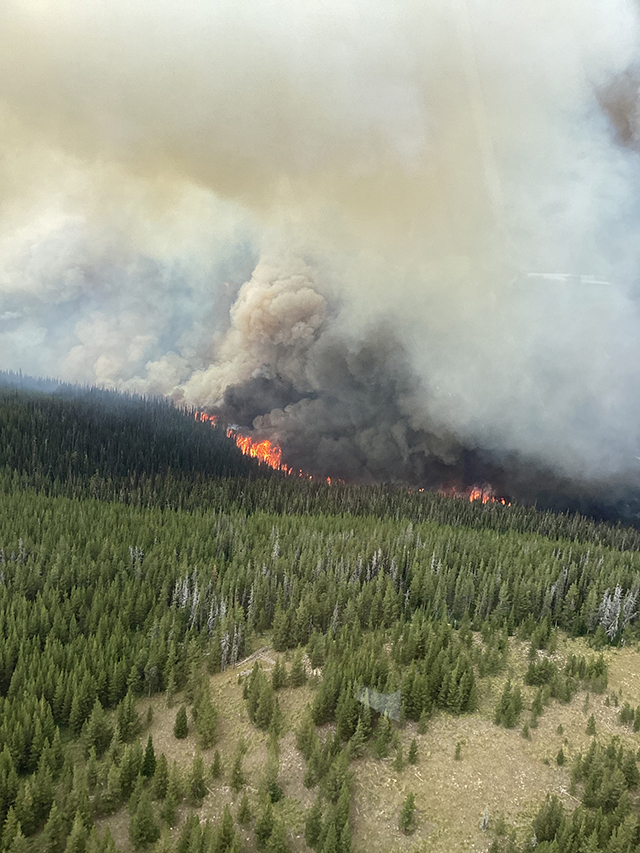 There is a lot of forest fire activity in the Nez Perce Clearwater National Forest. Shown is a Forest Service photo of the Williams Creek Fire. |
|